


The Families Who Saved the Buffalo
On any given summer morning, the Buffalo National River feels as if it...


It appears that you're using a severely outdated version of Safari on Windows. Many features won't work correctly, and functionality can't be guaranteed. Please try viewing this website in Edge, Mozilla, Chrome, or another modern browser. Sorry for any inconvenience this may have caused!
Read More about this safari issue.

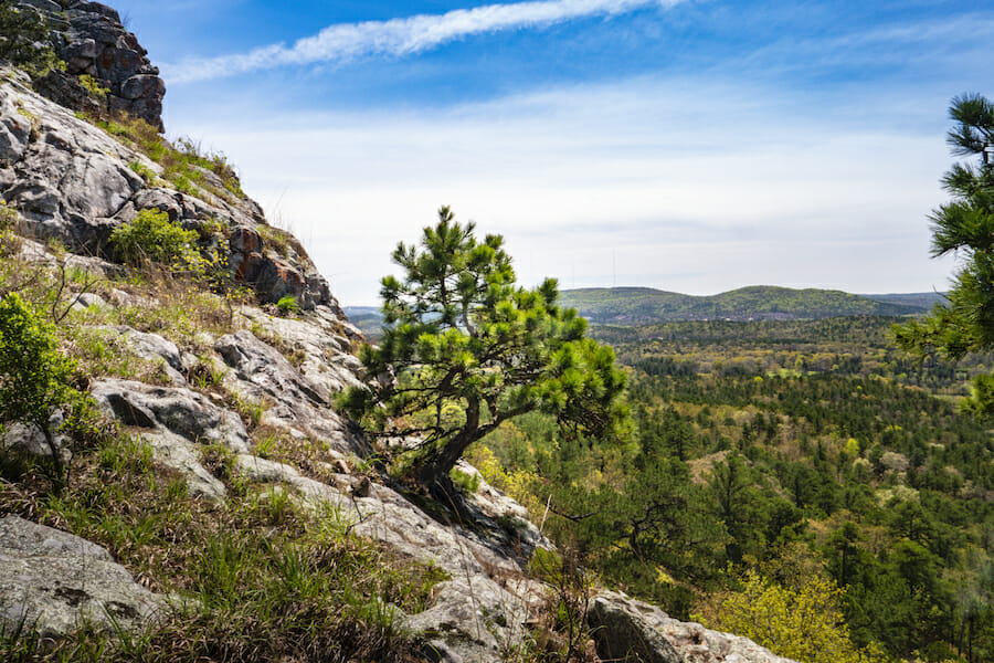
If you are looking for a challenging trail system in Central Arkansas that’s ideal for hiking, biking and climbing, head no further than Rattlesnake Ridge Natural Area near Roland. This system of trails is perfect for seasoned hikers and bikers looking for a moderate challenge. The payoff is a spectacular view of the Pinnacle Mountain area.

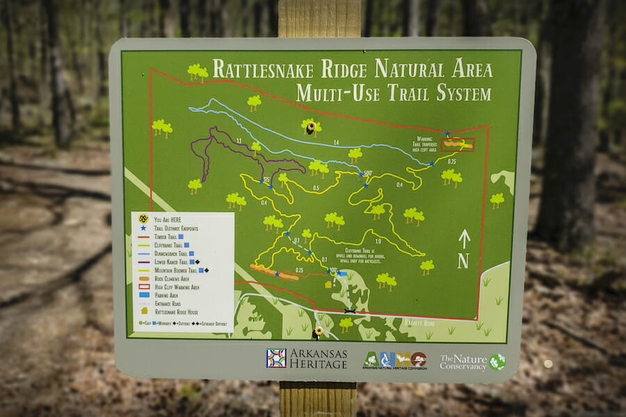
The Rattlesnake Ridge Natural Area is maintained primarily by the Arkansas Natural Heritage Commission and the Nature Conservancy in Arkansas. It includes over 6 miles of multi-use trails that are open to the public.
The conservation of this area is designed to protect a variety of rare plant and animal species, including the eastern collared lizard. The Mountain Boomer trail takes its name from this species of lizard which is the largest lizard found in Arkansas. Other species of concern which can be spotted on the trail include the western diamondback rattlesnake, the southeastern bat and Wright’s cliffbrake, a desert fern.
Conservation of this property also helps to protect Lake Maumelle, the primary drinking water supply for central Arkansas. The ridge is the watershed divide between the Big Maumelle and Little Maumelle rivers. It has a unique climate that supports rare plants and animals more typically found in western climates.
Rattlesnake Ridge is a stacked-loop system of trails. With a common beginning and ending point, users can navigate different parts of the trail depending on ability or available time. As you approach the posted trail map, you will see a service road to your right and the multi-use trails to your left.
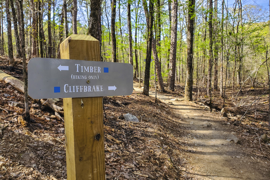
The Cliffbrake Trail is the most popular trail for hiking and ends at an overlook with a spectacular view before returning to the starting point. Mountain bikes are allowed on this trail for uphill portions only–no downhill travel. The rocky trail starts fairly easy but increases in elevation and difficulty as you get closer to the overlook at the loop’s halfway point.
The Timber Trail (hiking only) and the Cliffbrake Trail both have climbing zones that are popular with rock climbers. Several bolted routes ranging from 30-60’ in length are located at the Nowlin Climbing area just a short five-minute walk from the parking area. These are perfect for beginning climbers but should be fun for climbers of all skill levels.
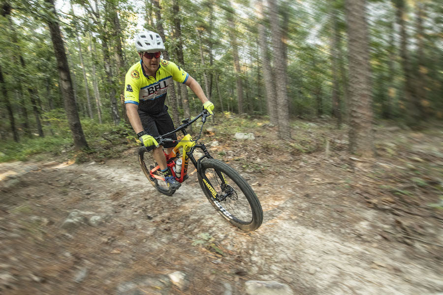
The Diamondback trail is popular for mountain bikers and offers an easy to moderate ride. The Lower Kanob and Mountain Boomer Trails both offer more challenging routes.
Along all of the trails you will see a variety of rock formations, native plants, and if you are lucky, you may spot a deer or even a bald eagle. And while you should always be aware of snakes, in particular rattlesnakes and other venomous snakes, most that you spot will be harmless.
At the junction of Interstate 430 and State Highway 10 in Little Rock, head west on State Highway 10 for approximately 8.5 miles. Turn right onto Barrett Road and travel 1.2 miles. The natural area is on the left side of the road.
Rattlesnake Ridge Trail Information Facebook Group
Rattlesnake Ridge Georeferenced Trail Map
This treasure of a trail system is located just outside of the heart of Little Rock yet overlooked by so many. If you are local, check out these trails as soon as possible. If you’re outside of Little Rock, I promise it’s worth the drive.
All photos are courtesy of Arkansas Department Parks, Heritage and Tourism.
Sign up for our weekly e-news.
Get stories sent straight to your inbox!


Like this story? Read more from Julie Kohl
Summer has a way of filling every available space on the calendar. One...
In light of America's 250th birthday, it's been fun to look back at how...
Camping is good for the soul. It connects you with nature and with your...
Join the Conversation
Leave a Comment