


Uh oh...
It appears that you're using a severely outdated version of Safari on Windows. Many features won't work correctly, and functionality can't be guaranteed. Please try viewing this website in Edge, Mozilla, Chrome, or another modern browser. Sorry for any inconvenience this may have caused!
Read More about this safari issue.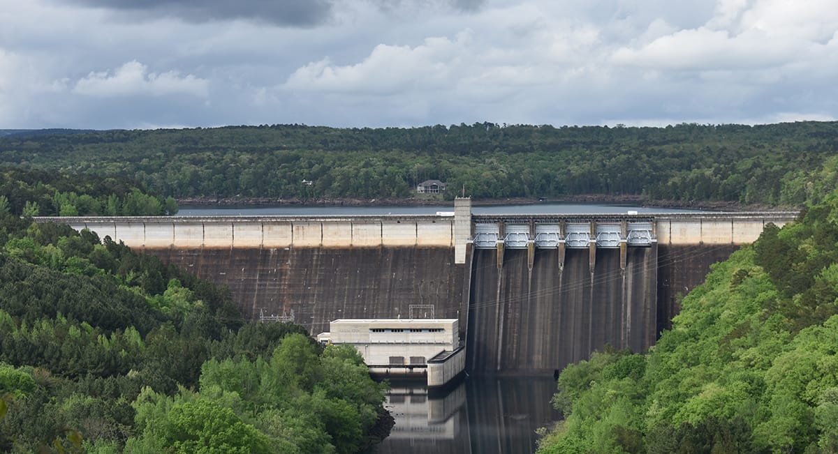

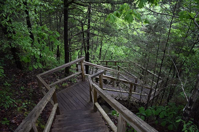
If you’ve ever traveled on HWY 25 through Cleburne County, chances are you’ve driven on the Greers Ferry Dam. You can’t see too much of the dam as you’re driving on it, but a stop at the John F. Kennedy Memorial Overlook, or a walk along the shore downstream reveals an impressive and awe-inspiring structure.
Equally impressive is the history of both the dam and the area in which it stands.
When Arkansas became a part of the United States in 1803 with the Louisiana Purchase, hunters, trappers, and settlers were only sparsely scattered near the White and Little Red Rivers. In 1820, this area was explored and mapped for the first time by Major Stephen H. Long, a member of the early Corps of Engineers. Major Long’s reports on the land and climate encouraged pioneers to settle in the Little Red River country.
As settlements grew near the Little Red River, the area’s waters became an important means of transportation. This generated a new role for the Corps of Engineers – to improve the safety and navigation on the rivers and streams.
During the 1800s, steamboats were a valuable means of transporting goods to and from the Arkansas wilderness. In 1903, the first railroad built in the area began operation, which soon ended the need for steamboat traffic on the White and Little Red rivers.
Later, the Spring of 1927 brought torrential rains and storms to the Mississippi Valley, which produced the greatest flood disaster in the history of the United States. This, combined with a long history of flooding in the Little Red River country, caused Congress to assign the Corps of Engineers to develop a flood control program.
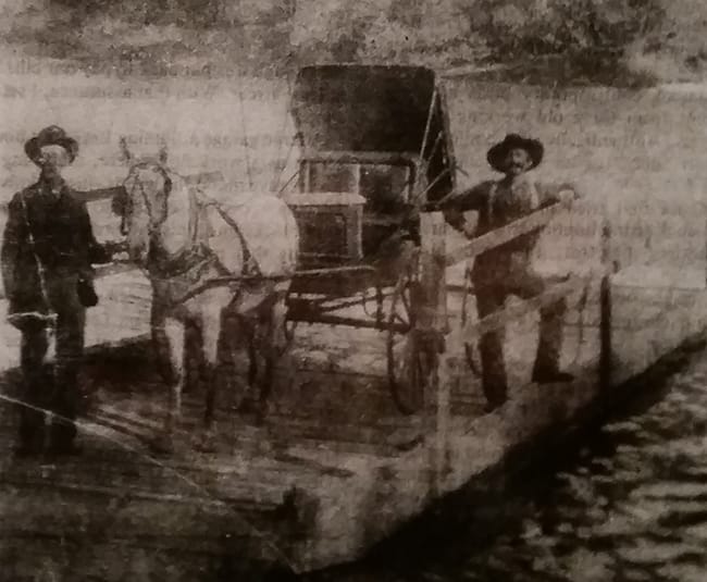
Image Credit: William Carl Garner Visitor Center
In 1938, Congress approved the Corps’ plan for a series of flood control dams on the White and Little Red Rivers, including a dam near Heber Springs. However, the onset of World War II caused these plans to be put aside.
Congress approved the building of Greers Ferry Dam in 1954. Local residents had worked for over 30 years to convince Congress of the need for the dam and had gained the backing of the Arkansas Legislature and concerned civic groups along the way. The final decision to build Greers Ferry Dam was based on two of the dam’s major benefits: flood control and the generation of hydro-electricity.
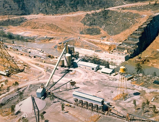
Image Credit: US Army Corps of Engineers
Nine years of planning and six years of work on the Greers Ferry Reservoir were completed before the first concrete was poured in 1960. The total cost of the project was $47.5 million. As soon as the dam was built, the Corps began filling the reservoir pool.
Construction of the dam and creation of the lake impacted many small towns in the area. At least seven towns had to be deserted because once the water rose, they would soon be underwater. Prior areas of Choctaw, Edgemont, Eglantine, Higden, Miller, Mudtown, and Shiloh are now at the bottom of Greers Ferry Lake. It’s also said that twenty-seven cemeteries were relocated. As you can imagine, controversies arose over the relocation of entire towns, utilities, the cemeteries, and a railroad. But the benefits of the dam eventually outweighed those complications.

After completion, the dam and lake were dedicated by then-President John F. Kennedy, which would prove to be his last major appearance before his ill-fated trip to Dallas in 1963. President Kennedy spoke about how the dam would impact both the local area and the country, and what he believed would be a major positive financial change to the area, and he was right.
Greers Ferry grew from an economically weak area into one of the most popular vacation destinations in Arkansas. The Corps of Engineers estimated that by the year 2000, over 5.5 million people had visited the lake and the surrounding area. A later estimate says that more than 7 million people visited in the year 2012 alone.
Greers Ferry Lake is considered one of the cleanest and most beautiful in the world, and gives its visitors opportunities to camp, hike, swim, boat, ski, fish, and sightsee.

Located near the dam, The William Carl Garner Visitor Center opened in 1983 and provides visitors with stunning exhibits and facts about the dam. The center tells the story of the Little Red River country, way back to prehistoric times, through exhibits, photographs, multi-image audiovisual presentations and live demonstrations.
I collected much of my material for this article from the William Carl Garner Visitor Center and give credit to the outstanding research on display there. The US Army Corps of Engineers was also very helpful to me and provides a wealth of information about the Greers Ferry Dam.
You can learn more about the dam, the visitor center and the US Army Corps of Engineers at http://www.swl.usace.army.mil/Missions/Recreation/Lakes/Greers-Ferry-Lake/Wm-Carl-Garner-Visitor-Center/ .

Greers Ferry Dam Fun Facts:
- 856,000 cubic yards of concrete were used to construct the dam.
- Pressure on the upstream side of the dam is 100 lbs./sq. in. It would take nearly twice that much pressure to turn the dam over.
- Discoloration on the face of the dam is due to residual elements of the oil used in the forms to keep the concrete from sticking.
- Controversy between fishing enthusiasts and the Corps over releasing cold water into the Little Red was resolved with the idea of stocking trout in the Little Red.
- Much of what is known about the geology and archeology of Greers Ferry was learned from the research done by archeologists when the dam was constructed.
- Since it was completed, the Greers Ferry Project has regulated more than 80 floods on the Little Red River. Accumulated flood losses prevented are estimated at over $50 million.
- Through 2012, the project has produced more than 9.2 million megawatt hours of electricity, which was marketed for more than $64 million.
- The project currently has a total of 994 developed campsites.
- The Greers Ferry Lake and Little Red River Cleanup program started in 1970, has won 16 Keep America Beautiful awards, six Take Pride in America awards (including the Hall of Fame Award) and was the model for the Great Arkansas Cleanup and National Public Lands Day.
- The Tumbling Shoals Bridge was once the longest suspension bridge in the United States, and was listed in Ripley’s Believe it or Not as the only bridge in the United States where one could see the end before the beginning. Construction began in 1912. It was dismantled when the dam was constructed.
- Once a big lumber town that once had over a thousand residents, Old Higden is now located under approximately 60-80 feet of water.

Like this story? Read more from Bryan Fiveash
 2
2
Music Roots Keeps Mountain View’s Folk Heritage Alive

If you visit Mountain View, Arkansas, you will likely find live music...
 1
1
The Paragould Meteorite
In the early morning hours of February 17, 1930, witnesses in Missouri,...
 3
3
Bronze Doors at the Arkansas State Capitol
The resplendent Arkansas State Capitol in Little Rock was built in 1915...
Join the Conversation
Leave a Comment
12 responses to “Greers Ferry Dam and William Carl Garner Visitor Center”
 Leave a Reply
 Leave a Reply
We do the work.
You check your email.
Sign up for our weekly e-news.
Get stories sent straight to your inbox!

[…] While camping and fishing take center stage in the Heber Springs area, a stopover at the JFK Memorial at the Greer’s Ferry Dam is worth the time. The views are stunning and the history is important. President Kennedy gave a […]
[…] out on the water, head to the left and you are about a 40-minute paddle from the Greer’s Ferry Dam. Head to the right and you can circle around a small island where you can even get out and explore. […]
[…] the influential people who played a part in President Kennedy’s 1963 visit to the area for the Greers Ferry Dam […]
[…] settled in Heber Springs where Tommy took a job with the Corp of Engineers as a park ranger at Greers Ferry Lake. And Debbie, a former home economics teacher, opened a gift […]
[…] family always goes to Heber Springs, Arkansas for trout fishing. The local dam (which is where we are for the photos above) divides a lake and a river which provides for any kind […]
[…] The visitor center is designed to showcase the history of the area culminating with the construction of the Greers Ferry Dam. The museum also contains a replica of the 40-pound, 4-ounce brown trout, caught on the Little Red River that held the world record as the largest brown trout from 1992 to 2009. You can read more about the visitor center here. […]
[…] National Recreation Trail is located behind the William Carl Garner Visitors Center in Heber Springs. The 660-foot long trail is fully paved and wheelchair accessible. If you visit […]
[…] Ferry Lake was formed in 1954 with the construction of the Greers Ferry Dam. The result was a 40,000-acre lake that has become a prime destination for hikers, campers, boaters […]
[…] stream flows from Greers Ferry Lake thanks to a restoration pipe added after the creation of the Greers Ferry dam. More of a wading stream than a swimming hole, the creek has tumbling falls and plenty of places to […]
[…] former ferries. Greers Ferry was named for a ferry that operated on the Little Red River. When Greers Ferry Dam was built to control yearly flooding, the name stuck. It now refers to the town, dam and lake. […]
[…] with Sugarloaf Mountain in Heber Springs, Sugar Loaf Mountain Island is located in the middle of Greers Ferry Lake between Fairfield Bay and Hidgen. This island juts 1000 feet above the lake and offers incredible […]
[…] Kennedy returned to the state in 1963 to dedicate Greers Ferry Dam. He drew a crowd of 5,000 to 10,000 people at the dedication ceremony, which celebrated the dam and […]