


NWA Summer Memory Makers
Summer has a way of creating memories that families talk about for years....


It appears that you're using a severely outdated version of Safari on Windows. Many features won't work correctly, and functionality can't be guaranteed. Please try viewing this website in Edge, Mozilla, Chrome, or another modern browser. Sorry for any inconvenience this may have caused!
Read More about this safari issue.

Some of Arkansas’s greatest treasures and attractions are its many lakes. The state has over 2,400 named lakes and reservoirs providing water, hydroelectric power, flood control and recreational opportunities to citizens and visitors alike. However, Arkansas’s rivers were once much less controlled, with federal jurisdiction over all interstate waterways. The Mississippi River and all of its tributaries could not be dammed or obstructed in any way unless Congress approved. The Mississippi, Ouachita and White Rivers in Arkansas were all under federal control, so though these rivers were cleared from debris for the passage of river traffic, dams could not be built for flood control. This left flood measures to a levee system enacted by local farmers and state governments. The levee system left the state vulnerable to flooding.

After the Civil War, as the population increased in Arkansas, communities took a greater interest in providing municipal services, including a reliable water supply. Reservoirs became a preferred method for supplying the increasing needs for water, resulting in some of the first dams in Arkansas. Despite significant flooding, levees were still the only means used to control flooding on the navigable rivers, until the Great Mississippi Flood of 1927. This flood broke through the levee system and inundated the Mississippi River Delta across Arkansas, Mississippi and Louisiana, displacing nearly 750,000 people and leaving land under six to 30 feet of water for months.
The Army Corps of Engineers designed a series of locks and dams, which provided the opportunity for both flood control and hydroelectric power. As the Great Depression hit in the 1930s, dam building became one of the great public works projects, solving flooding issues and providing work for many. Dam building continued after World War II as well. The largest Arkansas dams were built between the Great Flood of 1927 and the 1970s. The following six dams are just a sample of the many dams built across the state.

In 1954, Congress passed an act authorizing a dam on the upper White River in Northwest Arkansas. The dam would provide flood control and generate hydroelectric power while creating a water reservoir and recreational lake. The small community of Beaver, Arkansas, was one of the sites examined for the dam, although ultimately Busch, Arkansas, was chosen as the location. The first name stuck, though, and from 1960 to 1966, Beaver Dam and Lake were constructed. The lake provides 449 miles of shoreline in Benton, Carroll and Washington Counties and serves as the primary source of drinking water for Rogers, Bentonville, Springdale and Fayetteville. The dam generates $4.5 million in revenue from electricity (which goes to the cost of the facilities and repaying the federal investment). It also provides fishing, boating and other recreational opportunities that add revenue of $1 million in camping and day-use fees, with an estimated $30 million in visitor spending each year.

Bull Shoals Dam and Lake was a massive undertaking that the Corps of Engineers recommended in a report in 1940, along with Tablerock Lake in Missouri, to control flooding on the White River. Construction began in 1947. Five years later, President Harry S. Truman attended the dedication of the fifth largest dam in the nation. The dam is 2,256 feet in length and rises to 256 feet above the river. Though the dam provides hydroelectric energy, the lake it created is an amazing attraction. Bull Shoals Lake is the largest lake in Arkansas, with 1,000 miles of shoreline. The dam and lake created the town of Bull Shoals as investors flocked to the area in the late 1940s and early 1950s after seeing the potential for tourism. The resort town boomed with the exceptional trout fishing created by the cold water coming from the dam. Of course, fishing also abounds on the lake, and Bull Shoals became known for its excellent fishing opportunities. Now the town is a popular vacation spot and retirement destination. You can get a great view of the dam, the lake and read its history at the James A. Gaston Visitor’s Center.

Unlike the Corps of Engineer dams built for flood control, Arkansas Power and Light began examining the idea of dams for hydroelectric power in 1916. The first dam was built in 1924, near Jones Mill. The dam was named Remmel Dam and created Lake Catherine. In 1929, Arkansas Power and Light built the second of three dams on the Ouachita River. Carpenter Dam in Hot Springs created Lake Hamilton, which changed the face of the city and launched it as a vacation and resort destination. The construction took two years, and a self-sustaining work camp was set up to supply the men everything they needed, from a mess hall to a dance hall, and even a school for those who brought their families. Remmel Dam provided the energy required to complete the dam, which came online just as the Great Depression hit. Harvey Couch, the president of Arkansas Power and Light, named the dam after his friend, former riverboat captain Flavius Carpenter.

The Great Flood of 1927 left many communities along the Arkansas River devastated and in search of a way to control the river that crosses Oklahoma and Arkansas. The Arkansas River Flood Control Association formed and began a long battle damming the river faced one hurdle after another. First, the Corps of Engineers assessed the idea of a navigation system on the river to control flooding while maintaining valuable shipping. Though the Corps found the idea possible, they considered the project unfeasible. Fortunately, independent groups also submitted bids for a navigation system that Congress found acceptable. They approved the project in 1946. However, funding still had to be secured on a dam by dam basis, a daunting task in a system projected to have up to 20 locks and dams. In Arkansas, Senator John McClellan championed the project, winning funding for the system of locks and dams that now carries his name.

Work began in Oklahoma, but when the Korean War broke out, all work halted. It resumed in 1955 and construction on the Dardanelle Lock and Dam finally began in 1958, but the McClellan-Kerr Arkansas River Navigation System wouldn’t fully open for commercial use until December 30, 1970. The Dardanelle Lock and Dam is near the mid-point of the 448-mile long system and contains the Arkansas River Visitor Center, which overlooks the lock and dam. Lake Dardanelle offers over 34,000 acres of water, many recreational opportunities and Lake Dardanelle State Park.

Lake Fort Smith originally supplied the city with ample water. In the 1930s, the city built two dams and a water plant as part of a Works Progress Administration project – one dam at Lake Fort Smith, the other in Mountainburg at Lake Shepherd Springs. The project included a swimming pool, bathhouse, fishing ponds and other recreational facilities, which became Lake Fort Smith State Park in 1967. The lakes served the area well, but as the city’s population increased, officials realized they would soon run out of water. In 2002, the area began an expansion project that included conjoining the two lakes, building a new dam, and relocating the state park. The new dam is in Mountainburg, and the combined lakes created a 1400-acre reservoir that should serve the city and surrounding area well. The dam itself is 225 feet tall. Construction included acquiring 500 acres between the lakes, negotiating with the federal government to swap 570 acres of forest, and relocating two historical cemeteries. Once completed, the newly relocated Lake Fort Smith State Park opened at the original Shepherd Springs Dam site.

Greers Ferry Dam was part of the Corps of Engineers’ vision for flood control along the White River. Located in Cleburne County, the Corps waited until 1959 to begin construction, even though the site was surveyed after the passage of the Flood Control Act in 1938. After building Norfolk, Table Rock and Bull Shoals Dams, the Corps turned its attention to the Little Red River, which flooded every year and contributed to flooding downstream on the White River. The site selected, three miles north of Heber Springs, was not without controversy. The dam flooded the communities of Edgemont, Higden, Miller and Shiloh and many acres of bottomland used for farming. However, the dam completed the series of five Corps of Engineer dams along the White River watershed, a massive undertaking that had immediate impacts on the surrounding communities.
Along with flood control, the area gained both hydroelectric power and beautiful Greers Ferry Lake, which includes 340 miles of shoreline in Cleburne and Van Buren Counties. The area surrounding the lake bloomed into an active tourism center catering to boating, fishing, scuba diving and other water sports. The cold water in the Little Red River, which still flows beneath the 243-foot dam, harbors rainbow trout raised at the Greers Ferry National Fish Hatchery. The William Carl Garner Visitor Center is also a popular destination and houses the history of the dam, along with displays over area wildlife. The dam was dedicated October 3, 1963, by President John F. Kennedy.
The dams built across Arkansas have been controversial at times. Still, overall, they have allowed greater use of agricultural land, controlled rising floodwaters, produced hydroelectric power and given Arkansans and visitors innumerable opportunities for recreation around the many waterways surrounding the dams.
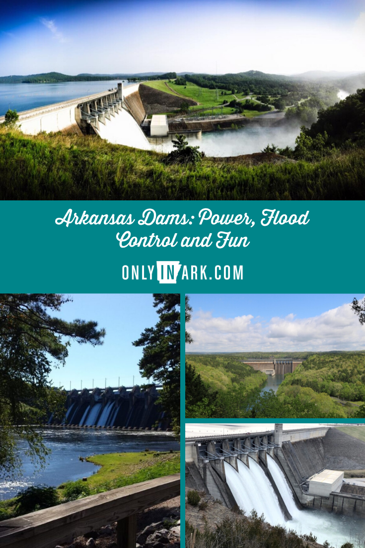
Header photo of Beaver Dam by Patrick Danko/United States Army Corps of Engineers.

 0
0 Women’s professional sports are having their moment. TV coverage and...
 0
0 In 1875, a simple homestead became a source of healing, if only according...
 0
0 The stagecoach is one of the most iconic representations of the Old West,...
Leave a Comment
 Leave a Reply
Sign up for our weekly e-news.
Get stories sent straight to your inbox!


[…] After the Great Flood, Congress enacted the 1928 Flood Control Act. This act put the U.S. Army Corps of Engineers in charge of rebuilding the levees along the Mississippi. In addition, they built a series of 29 locks and dams and hundreds of canal runoff channels to avoid such massive flooding. Another flood followed the Great Flood in 1937, but this time the levees held. After the Great Depression, an even greater push for flood control created many of the dams in Arkansas. […]
[…] prompted the federal passage of the 1928 Flood Control Act. That act changed the landscape as many Arkansas dams were built to ensure such a devastating flood never occurred in the state […]
[…] returned to the state to dedicate Bull Shoals Dam. In his speech, Truman continued to push for more dams and flood control in the […]
If we have a earthquake and all the dams break in Arkansas where if anywhere would there be any dry land to survive?